
Maps and rides
Thanks to Helen Beggs and Brad Phillips who wrote the bulk of this article back in 1997 when they rode around Tasmania and Wayne Kelly and other volunteers. It’s since been updated by riders who’ve sent in changes and tips. If you ride around Tasmania and think this description needs updating, email us at tasoffice@bicyclenetwork.com.au. To view the route’s distance and elevation visit our Ambassador routes page on the RidewithGPS app. We’ve split the ride into two parts. https://ridewithgps.com/ambassador_routes/2271-giro-tasmania-3-weeks-part-1-hobart-to-l https://ridewithgps.com/ambassador_routes/2288-giro-tasmania-3-weeks-part-2-launceston- This is a guide only. Use it as a starting point for planning your trip. Australia’s island state of Tasmania is compact, diverse and ideal for cycle touring. It has a temperate climate and loads of contrasts, from white, deserted beaches, to rugged mountains and rain forests, wild rivers, and historic villages. More than 20% of the state is National Park and much of that is listed as World Heritage. If you have at least three weeks to spend in Tassie then have a look at our detailed guide (below) to the “Giro Tasmania” which is an independent cycling tour right around the State, taking in many of Tasmania’s highlights. This tour is nearly entirely on sealed roads and we list both the camping and cheapest non-camping accommodation options. An alternative to the Giro Tasmania is the Tasmanian Trail, which is a mountain bike, walking and horse riding route made up of roads, fire trails and trails stretching from Devonport on the north coast to Dover in the south. Note: the Tasmanian Trail is for serious mountain bikes and is unsuitable for road bikes, parts of the trail are very rough and involve hauling bikes and bags. The Giro Tasmania tour as listed below assumes a start and finish in Hobart, Australia’s second oldest state capital, but it could just as well start from Launceston in the north of the State or Devonport, which is served by vehicle ferry from Melbourne. Starting from Hobart, it is recommended that you ride anti-clockwise around the State, beginning with the easier cycle up the East coast and finishing with the prevailing westerlies at your back as you cycle over the central highlands from the West Coast back to Hobart. If you start in Devonport or Launceston then it is recommended that you cycle the Giro Tasmania route clockwise, so that you will be fitter by the time you have to climb up to the central highlands. Although most cycle tourists take the “easier” option of only riding the East Coast, imagining the West Coast to be more hilly and windy and therefore more difficult, West coast roads are often better graded, more shaded by trees and protected from winds, and the scenery more attractive than the predominantly rural east coast. So, you’ve just stepped off the plane at Hobart airport and are wondering what’s happened to your precious bike. The Skybus provides a frequent service and has several inner city stops. Best to book online, and just ask the driver if you are uncertain about how to get to your final destination. You can hire a quality touring bike through Longhaul Tasmania, or check our list of bikeshops/bikehire options. You may be able to buy a bicycle in Hobart and sell it back to the same shop when you finish the Giro. Hobart is well-served with outdoor equipment shops (there is a cluster of them in Elizabeth St, just up from the mall), so you’ll have no trouble buying a tent, sleeping bag, camp stove, outdoor clothing, etc. A lower cost option is Recycled Recreation, which sells good quality second hand outdoor gear. Hobart is Australia’s second oldest city and has a wealth of scenery to explore by bicycle. Check out our other Ambassador Routes for curated self-guided tour options. You could cycle around the historic homes of Battery Point then head up Davey Street to the panoramic view from the top of kunanyi/Mt Wellington (1270m high). Salamanca Market down on the docks each Saturday (8am – 3pm) is a must-see for every visitor and a great place to pick up souvenirs and gifts. The Farmgate Market in Bathurst Street every Sunday morning is a good spot to pick up farmfresh produce and treats. There are tours of Australia’s oldest brewery (Cascade Brewery). For a good meal either head to Sullivans Cove for fresh fish and seafood, the trendy cafes in Salamanca Place or head up Elizabeth Street to North Hobart’s “restaurant district”. This is the shake-down day when you get used to the idea of cycling with all that gear! A pleasant cycle through farms and forest to the historic tourist village of Richmond. Keep an eye out for the ostrich farm a few kilometres before Richmond. If you start from the New Town YHA then the best route is: from Stoke St turn left into Park St, right into Bishop St, left at Bellevue Pde, right towards the train line and left onto the InterCity Cycleway which runs along the disused train line – head North. From here on you can follow the RideWithGPS map and self guided navigation cues. Just before the town of Richmond there is a well-marked turn-off to a camping ground (picnic shelters, swimming pool, trees, shop). There are public toilets in the town centre, small supermarket (7am – 7pm, EFTPOS), post office, pub, and a bakery and range of tearooms and restaurants. Camp at Richmond Cabin & Tourist Park, Middle Tea Tree Rd, (1km W of PO), Ph: (03) 62 602192 (covered cooking areas, picnic shelters, trees, indoor swimming pool, tennis court). And a wide range of B&B acommodation is available. This is a scenic ride along smooth sealed roads, but unfortunately you’ll be sharing the A3 with log trucks. Take special care between Buckland and Orford where there is no shoulder in parts and the road is very narrow. Alternatively, cycle the Buckland – Orford section on a Sunday, when there are the least number of log trucks, if any. Another alternative is to take a two day side trip to visit Port Arthur (extra 118 km) to explore the beautiful Tasman Peninsula and the historic convict prison. You would return to the east coast road at Orford via Copping, C335, C320 via Spring Beach. Buckland (at 40km) is the first chance to buy food/drink since Richmond, so you may wish to carry a cut lunch and plenty of water. Buckland has an Inn, grocery store, takeaway food shop and public toilets next to the hall. Orford is a pretty town with plenty of food shops, take-aways, a pub, post office and public toilets. There is no place to camp in Orford but Raspins Beach (1.5km along the A3 north of the Orford bridge) is a convenient place to rest/eat/swim and has a stunning view across to Maria Island. It can be quite noisy if log trucks are in operation. Triabunna (8km north of Orford) has some accommodation choices and less traffic noise, being off the highway. Triabunna is a larger town than Orford and has a large supermarket (9:30am – 6:30pm, EFTPOS), post office and a Westpac Bank branch at 17 Vicary St. Camp at Triabunna Caravan Park, 4 Vicary St, Ph: (03) 6257 3575. Or The Udda Backpackers, 12 Spencer St (03) 6257 3575. Side Trip to Maria Island: Catch the ferry from Triabunna to beautiful Maria Island, where you can camp or stay in convict cells! Eastcoaster Resort, Louisville Point Rd ph: 62 571172 Island View Motel, Tasman Highway ph: 62 571114 Miranda Cottage, Tasman Highway ph: 62 571248 Maria Island Ferry Co ph: 0419 746 668, e: info@mariaislandferry.com.au Continue along the A3 through undulating farmland to Little Swanport (29 km) (no shops or drinking water), where you can stop for lunch at the Little Swanport River Bridge (pit toilet). The road then hugs the coast with spectacular views most of the way to Swansea. Swansea is a charming, historic seaside town and has accommodation, supermarket, restaurants and a post office. Camp at Swansea Caravan Park, Shaw St (northern side of Swansea), ph: 62 578177. You can also camp at Mayfield Beach (42 km from Orford), off the A3, but there is no drinking water. There also may be cheaper camping available at Swansea Hostel on the North edge of town. Cycle north along the A3 to Cranbrook (16km) (no shops) through undulating farmland. There are several options for wine tastings and gourmet lunches/platters. For example, Freycinet Vineyard (27km). A side trip to Coles Bay (extra 20km) to explore the stunning Freycinet National Park will take you at least one extra day. Continue along the A3 to Bicheno, sun capital of Tasmania and home to a fairy penguin rookery and a beautiful beach and foreshore. There are keycard facilities at the post office, and a variety of shops and restaurants. Camp at Bicheno Cabin and Tourist Park, Champ St, Ph: (03) 6375 1117. There is a hostel in the centre of Bicheno (Bicheno Backpackers. This has to be one of the most breathtaking rides in Australia! The route along the A3 hugs sparkling white and turquoise blue deserted beaches all the way to St Helens. Start early in the morning and carry a cut lunch and plenty of water so you can stop at some of the lovely beaches along the way. You may like to stop at the East Coast Birdlife and Animal Park (7km) which has Tasmanian Devils. The nondescript seaside town of Scamander (5 km) has public toilets, drinking water, supermarket with EFTPOS, accommodation and caravan park. There’s also free camping in the woods at Shelly Point a few minutes north of town. St Helens is a popular resort/fishing town with magnificent coastal scenery and unspoilt beaches. There are ATMs, shops, restaurants and accommodation. Camp at St Helens Caravan Park, Penelope St, (1.5km S of PO), ph: 63 761290, or stay at St Helens YHA Hostel, 5 Cameron St, St Helens 7216, ph: 63 761661. St Helens Big 4 Holiday Park has mountain biker container style accommodation, and on the way out of town is Gravity Lodge, also bike friendly. A hilly ride along the A3 through spectacular stands of rainforest and over Weldborough Pass (600 m). Watch out for log trucks. The Weldborough Pass Rainforest Walk (10 minute circuit) is well worth a look. Weldborough (47km) was a rather quaint near-ghost town, once a bustling centre for tin-mining, but is now lively with MTB riders visiting the Blue Derby MTB trails. Lunch and dinner may be obtained at the Weldborough Hotel, which calls itself (tongue in cheek) as the ‘Worst Little Pub in Tassie’, and also provides reasonably priced accommodation, ph: 63 54 2223, or very cheap tent sites in the adjoining Weldborough Camping Ground. If you can manage another 200m climb and don’t wish to camp, then continue another 21km along the A3 down a long, thrilling descent through more rainforest, followed by a climb to the very pretty, historic tin mining town of Derby (museum, meals, post office, public toilets). There is now a range of accommodation options here, best to book ahead. In Derby, also check out the Sauna on the Lake (bookings essential). A surprisingly hilly ride today along the A3 and B81, so a good idea to start the day early. We recommend taking the nice little Derby-Branxholm offroad trail, which is slightly downhill and misses a hill on the main road. Branxholm (7km) has a camping ground (enquire at Post Office), but you can’t drink the tap water without boiling it first. The A3 continues through undulating farmland toward Scottsdale (31km). On Billycock Hill, just past the turnoff to Legerwood you can find the entrance to the North East Rail Trail – this is unsealed but a nice offroad alternative if your bike is sturdy. At Scottsdale you’ll find accommodation and meals at Lords Hotel, public toilets, shops, restaurants, post office. At the entrance to Scottsdale is a pleasant, small camping ground, adjacent to a birdlife reserve. If you stayed at Weldborough the previous night then this would be a good place to camp. From Scottsdale take the B81 to Lilydale Falls and stop off at Clover Hill winery along the way to sample their excellent champagne (wine tastings daily 10 am to 5pm). Camp at the picnic area/tents-only camping ground at Lilydale Falls Reserve (2 km north of Lilydale), or stay at Falls Farm (BB), 231 Golconda Rd, Lilydale (100m south of Lilydale Falls Reserve), ph: (03) 6395 1598. If you are planning to camp at Lilydale Falls then stock up with food at Scottsdale. There are toilets, picnic shelters, tables and drinking water in the reserve. This is a particularly lovely, peaceful place to camp and highly recommended. Cycle 2 km along the B81 to Lilydale village (supermarket open 7am – 7pm daily) and continue through attractive, hilly forest to Rocherlea (21 km). From Rocherlea follow minor roads and cycle way into the centre of Launceston (30km). Camp at the Treasure Island Caravan Park, 94 Glen Dhu St, South Launceston (2 km S of PO), ph: 63 44 2600, or stay at Launceston City Backpackers, 139 and 173 George St, ph: 63 34 2327. Alternatively, continue right through Launceston and along the old Bass highway to Deloraine (51km), a long day but relatively flat cycling after Launceston. From Launceston, take Hwy 1 south-west and take the turn-off to Hadspen (14km) along the old Bass Highway, B54. Continue through Carrick (20km) (meals, accommodation) then rejoin Hwy 1 before Hadley (30km) (meals, toilets, shops). The old Hwy 1 is narrow but not too busy through Westbury (35km) (bakery, toilets, shops, accommodation) and about 5km west of the town you can rejoin the B54 to escape the traffic by taking the turn-off to Exton. The rest of the cycle is very pleasant, passing through attractive farmland along the B54 to Deloraine (bank, supermarket, shops, meals, accommodation). Camp at the Deloraine Apex Club Caravan and Camping Park (follow signs from the bridge) or stay at the Deloraine Backpackers Hostel, 24 Bass Hwy, Ph: (03) 6362 3408. Head out of Deloraine along the B12 to Mole Creek (27km). At the Trowunna Wildlife Park (600m off the B12 about 4 km before Mole Creek) you can see koalas, Tasmanian Devils, wombats and wallabies. Keep an eye out for their giant wooden Tassie Devil by the side of the B12. You may like to camp at Mole Creek Camping Ground, Sassafras Creek, (4 km W of PO on the B12), Ph: (03) 6363 1150, or stay at the Mole Creek Hotel, Main Road, Mole Creek 7304, Ph: (03) 6363 1102. Meals are available at the Mole Creek Hotel and Wandering Trout bistro. From Mole Creek continue along the B12 for 4km to Sassafras Creek (Mole Creek Camping Ground) and take the C137 turn-off north over the Gog range (a steep little hill) to the whisically named hamlet of Paradise. A remarkably beautiful cycle over the Gog Range and around Mt Roland. Turn South along the C136 to the old Hydro-electric village of Gowrie Park, set amidst towering mountains and forests. The scenery is so good you may be tempted to stay, as the accommodation is much cheaper (and quieter) than at Cradle Mountain Camp. There is a Caravan Park on the C136, (large picnic shelter, toilets, drinking water, trees, no showers). Or choose “Gowrie Park Wilderness Village” (formerly Wild Gowrie Park), 1447 Claude Road, ph(03) 64 911385. They have an ensuite style amenity block, self-contained cabins, powered or unpowered camp sites, as well as individual backpacker rooms, a laundromat and internet access. There is a large picnic shelter, shade, drinking water. A steep but very scenic and rewarding ride up through rainforest and alpine scrub into the “high country”. Give yourself plenty of time, as you’ll be gaining a lot of height. From Gowrie Park you will have a thrilling hair-pin descent down the C136 to the Cethana Dam, but then a gruelling climb up the other side of the valley to Moina (14km) (where you may find accommodation, cafe, limited groceries, check websites for updates). From Moina, head south along the C132, through a desolate, alpine plateau, and follow the signs to Cradle Mountain National Park. Groceries may be obtained from the general store at the Pencil Pine township at the gates to the park. Camp at the Parks and Wildlife Campground Ph: (03) 6492 1133 or at Cradle Mountain Campgrounds, Cradle Valley, Ph: (03) 6492 1303. Bookings are essential over the peak summer and Easter periods. Accomodation is available in bunkhouses and cabins at the Cradle Mountain Campgrounds. Side Trip to Dove Lake: After cycling so far, it would be a shame not to cycle to famous Dove Lake (11km from Cradle Valley camping ground) and spend at least a day exploring this rugged World Heritage Area on foot. Walking: (At least one extra day).There are lots of great day walks to do around the Cradle Mountain/Dove Lake area. These can all be started from the Dove Lake carpark. You’ll need a good raincoat , warm clothes (be prepared for snow/sleet!), sturdy walking boots and a day pack. From the camping ground at Cradle Valley, cycle 11km south along the C132 to the Dove Lake car park, where you’ll have to leave your bike. Along the way, visit the Visitor Centre, short nature walks and the Waldheim museum. Day walks from Dove Lake: Twisted Lakes (5km, 2 hours return); Marions Lookout (5km, 3 hours return); Lake Dove Circuit (7km, 3 hours return); Lake Rodway (10km, 4.5 hours return); Hansons Peak, Lake Hanson and Twisted Lakes (6 hours return) – difficult. Cradle Mountain summit (12km, 4.5 hours return) – Highly recommended. A spectacular ride today through alpine moors then alpine forest of celery top pine and myrtle, with only one small hill from which there is a breathtaking view of Cradle Mountain and Mt Pelion. The rest of the cycle is gently undulating or downhill. There are no shops or sources of drinking water for the first 54km so make sure you carry plenty of water and lunch. From Cradle Mountain head west along the C132 and then south along the A10 to Tullah (54km) (cafe, takeaway, some groceries, toilets, pub, accommodation, wild camping by river). After Tullah, the A10 climbs for 4km through beautiful rainforest to the top of Mt Black, followed by a thrilling descent to Rosebery (pub, supermarket, takeaways, accomodation, post office). Rosebery is an old west coast goldmining town and going there is like stepping back about forty years to the old-style Australian country town. Everyone seems to have time for a chat. Camp at Rosebery Caravan Park, Park Road, Ph: (03) 6473 1366, (great picnic shelter!). Alternatively, stay at Mt Black Lodge Hostel, Hospital Road, Ph: (03) 6473 1247. Side Trip to Montezuma Falls rail trail: If you have an MTB and an extra half day then highly recommended is a short detour to Tasmania’s highest waterfall, Montezuma Falls, just south of Rosebery. If you do go to the Falls then you will probably want to camp or stay in Zeehan, rather than pushing on to Strahan. Montezuma Falls – One extra half day: A highly recommended side trip for MTB’ers is a quick detour to Tasmania’s highest waterfall, Montezuma Falls (at 113m), just south of Rosebery. About 2km south of Roseberry along the A10, turn off to Williamsford (6km)along a sealed road. From there it is bikes and walkers only, along an old train line. The 5km track to Montezuma Falls is lovely, with large cuttings, a nice constant and gentle gradient and greenery all around. The return trip to the Falls from Rosebery takes about 3 hours. The first 20 km are rather hilly but through pretty rainforest, followed by a long, flat or gently downhill run through button grass plains and coastal scrub. From Rosebery continue south-west along the A10 and take the B27 to Zeehan (30km) (post office, takeaways, accomodation, caravan park, toilets, shops) – a good place to stop for lunch and to have a look at their excellent mining museum. Continue along the B27 for 42km to Strahan (post office, toilets, supermarket, bakery, restaurants, pub, accommodation). Strahan is a cosy little fishing village on Macquarie Harbour, steeped in the convict and pining history of the rugged West Coast. “Piners” used to row wooden boats up through the rapids of the Gordon, Franklin and other rivers of Tasmania’s South West wilderness, in their quest for the endemic Huon Pine. Camp at Strahan Beach Tourist Park, or try Strahan Backpackers, 43 Harvey St, Strahan 7468, ph: (03) 6471 7442. Side Trip up the Gordon River: Just about every visitor to Strahan takes an all day cruise up the world-famous Gordon River (fed by the Franklin River) in the Tasmanian Wilderness Heritage Area. After travelling all that way to Strahan you really shouldn’t miss it. Although you will climb a total of about 700m, the cycling is surprisingly easy due to well-graded roads making the climbs long but comfortable, usually with the prevailing westerly winds at your back. Carry lunch and plenty of water. From Strahan take the B24 up the long hill to Queenstown (42km) (post office, pubs, Trust Bank, supermarket, toilets, takeaways, meals). Queenstown is your last chance to buy groceries for 175km. Queenstown has the dubious distinction of being the only place in the world which treasures its lack of trees, caused by the noxious fumes of an earlier copper smelter. The starkly bare hills have for many years been a tourist drawcard, but to the locals’ horror, the trees are now growing back! Queenstown has a great attraction- the Abt Wilderness Railway (ph: 6471 1700). Check the website for details and to make bookings. A wide range of accommodation is available in Queenstown. The cheapest is the Queenstown Cabin and Tourist Park Hostel, 17 Granton St (1 km PO), Ph: (03) 6471 1332, or Mountain View Holiday Lodge Hostel, 1 Penghana Rd, Queenstown, Ph: (03) 6471 1163. Either stay in Queenstown or continue along the A10 the 23 km to Lake Burbury. About 3km after the Lake Burbury bridge there is a picnic area sign, pointing along a road to your left. This “picnic area” is an enormous grassy expanse, with lots of windbreaks of trees, on the banks of a large man-made lake, and is a beautiful, clean and peaceful place to camp. The huge picnic shelter with tables and benches provides welcome shelter from rain. Camp at the picnic area on the eastern shore of Lake Burbury (toilets, drinking water, large picnic shelter, gas BBQs, no showers). You will need to have stocked up with a couple of days of food in Queenstown. You will climb 900m today, so start early (especially if you are staying in Queenstown). The day involves a ride along the A10 through the Tasmanian Wilderness World Heritage Area over spectacular mountains, through magical rainforest and over wild rivers. Traffic is fairly light. If time permits, the following short walks from the A10 are highly recommended: Donaghey’s Hill (45 minutes return walk from highway), Franklin River crossing (10 mins nature walk), Franklin River flying fox (10 mins walk along Frenchmans Cap Walking Track), Franklin River Nature Trail. From Lake Burbury the A10 climbs gently for 11km to Victoria Pass (530m) then continues through rainforest. There is easy cycling until the Franklin River picnic area (41km) (picnic table, drinking water from river). After the Franklin River, the A10 climbs steeply through rainforest for 10km with spectacular views of Surprise Valley and Mt King William. At the top are button grass plains and eucalypts – a flat cycle for the 16km to Derwent Bridge (67km) (accommodation, meals). Take the turn-off to Lake St Clair and climb gently for 5 km to the Lake St Clair National Park (camping area, bunkhouses, restaurant and limited groceries). Lake St Clair is at the southern end of the Cradle Mountain/Lake St Clair National Park, and is surrounded by rainforest and mountains. There is a camping ground at the end of the road, by the lake (hot showers, laundry), or you can stay in a cabin, ph: (03) 6289 1172 (bookings essential). Alternatively, if you wish to skip Lake St Clair, then you can stay at Derwent Bridge Wilderness Hotel, Lyell Highway, Derwent Bridge 7140, (500 m NW of PO), Ph: (03) 6289 1144, Fax: (03) 6289 1173. Meals are available at Derwent Bridge Wilderness Hotel. Side trip: Walks around Lake St Clair World Heritage area (at least one extra day). From the camping ground at the southern end of Lake St Clair there are numerous day walks, but you’ll need a good raincoat, warm clothes, a day pack and walking shoes. Enquire at the Ranger Station about day walks. Alternatively, you could catch the shuttle boat from the jetty near the camping area to Narcissus Bay on the northern shore of the lake and walk back to the camping ground along a track through the rainforest (3+ hours, easy). There are prevailing westerly winds and a significant altitude loss, so this is quite an easier day’s pedal than Day 15. From Derwent Bridge follow the A10 for 20km, then take a short cut to the right along the C601 for 20 km to avoid the steep hills around Tarraleah. CAUTION: This road is unsealed and sometimes rough and narrow but is 11km shorter than the hilly main road. Watch out for the odd truck. Continue on the A10 another 11km and take the turn-off to the immaculate, nearly deserted Hydro-electric town of Wayatinah (food shop (9:30 am – 11:30 am daily), tavern (4 pm – late)). Follow the signs to the camping ground. Camp at Wayatinah Camping Ground, by Wayatinah Lagoon, ph: (03) 6289 3317 or (03) 6244 4271 (heated outdoor swimming pool, BBQ, tennis court, showers, laundry) – highly recommended. There is also a free camping area just over the C608 bridge approximately 2km from the turn-off with the A10 (93km from Lake St Clair) (toilets, drinking water from lake). Ouse (76km from Derwent Bridge) has accomodation at Sassa-del-Gallo holiday units, Main Road, Ph: (03) 6287 1289 or 6287 1263, and at the Lachlan Hotel, Lyell Highway, ph: (03) 6287 1215. Cycle back to the A10 and head to Ouse (25km) for lunch. Ouse has a hospital, post office, takeaways, supermarket, meals at Lachlan Hotel and public toilets. Continue along the A10 for 7km and turn right onto the C608, a lovely quiet country road (but hilly!) which will take you through attractive farming country to the pretty village of Ellendale (45km from Wayatinah). Ellendale has self-contained accomodation at Hopfield Cottages (bookings essential – ph: (03) 6288 1223), a post office, shop (open 9am to 5pm), public toilets and a very nice picnic shelter by the creek with possible camping sites. Keep an eye out for the interesting, wooden oast houses, used for drying hops. Another 10km along the C608 is the turn-off to Westerway along the B61. Westerway has food shops – there is a limited kiosk at Mt Field. Continue 7km along the B61 to Mt Field National Park , one of Tasmania’s most popular National Parks. Home to the spectacular Russell Falls, the park boasts scenic rainforest, some of the world’s tallest trees, deep mountain lakes and abundant tree ferns. Meals are available at the pub and there is a cafe at the visitors’ centre in the park. Camp in the camping ground just inside the park gates, ph: (03) 6288 1149 or stay at the Mount Field National Park YHA Hostel, ph: (03) 6288 1369. Note: we have rewritten this section because construction of the Bridgewater Bridge is making it dangerous for riders. Head back along the B61 and continue through pretty hop farming country to Bushy Park (18km), which has a takeaway shop. From Bushy Park, take the B62 (Glenora Road) through some stunning rural scenery along the Derwent River past the Salmon Ponds (29km) (museum and restaurant) to New Norfolk (38km). Camping sites are available at the New Norfolk Caravan Park, Esplanade, ph: (03) 6261 1268, and cheap accomodation at the historic Bush Inn, 49 Montagu St, ph: (03) 6261 2011. New Norfolk town has a wide range of shops (including a bike shop in Richmond St, ph: (03) 6261 2201) and cafes. Leaving New Norfolk, many riders usually prefer to cross over the bridge over the Derwent River and turn right onto the relatively quiet B10 to Bridgewater. This avoids the narrow and very busy A10. However major works on the Bridgewater Bridge mean there is no safe access for riders on either side of the river at that point. So it is currently best to stay on the southern side of the river and take the scenic (and hilly) detour through Molewsorth. Take the Lyell HIghway (A10) towards Hobart. Turn right onto Molesworth Road and do some climbing, and then a great descent, to finally reach the safe and pleasant InterCity Cycleway which will take you to Hobart’s waterfront. To get to the Newtown YHA turn right from the cycle path into Oldham Avenue, left into Park St and right into Stoke Street. Camp at Treasure Island Caravan Park, Main Road, Berriedale (on Giro route, 14 km from GPO), Ph: (03) 6249 2379, or stay at YHA hostel “Adelphi Court”, 17 Stoke St, New Town, Tas 7008, ph: (03) 6228 4829 (bookings essential) or at Transit Centre Backpackers, 199 Collins St, Hobart (city), Ph: (03) 6231 2400. The Old Woolstore Hotel has secure bike parking and a washdown station. All telephone numbers are listed without their “STD” (within Australia) area code, which is 03 for all of Tasmania. Callers from overseas should use the international+area code +61 3 in place of 03. In the on-road sections of this ride, the traffic is usually quiet. However, even in country towns, be careful as you check to see what the traffic behind you is doing, indicate, and “take the lane” as necessary (this means, move into the centre of the lane to discourage a driver from trying to squeeze past you). On country roads in Tasmania, the speed limit is 100 km/hr, and there is often no shoulder to “hide” on. Experienced riders ride on the painted lane marking and watch for vehicles coming from behind. Cyclists are permitted to travel two abreast, not more than 1.5 metres apart, but be prepared to go single file when vehicles approach from behind, as a courtesy. Tasmania has a “minimum passing law”. When passing a cyclist, driver must maintain a safe passing distance of: …At least 1.5 metres in speed zones higher than 60 km/h …At least 1 metre in 60 km/h or lower speed zones This law applies to all roads, even where there are bicycle lanes. Vehicles are permitted to cross unbroken centre lines to overtake bicycles, if it is safe to do so. Bright clothing and flashing lights – white on the front, red on the back – can improve your visibility on country roads. The weather in Tasmania is notoriously changeable, so take another layer with you. Don’t forget sunscreen, Tasmania has high UV levels all year round. Richmond – Port Arthur (82 km), Port Arthur – Dunalley (41 km), Dunalley – Orford (50 km – including 29 km unsealed) At least two extra days.Port Arthur is Australia’s best known historic penal settlement, dating back to the years of convict transportation. For the adventurous, there are Port Arthur Ghost Tours during the evenings complete with real ghosts! There are great coastal walks and natural features, such as the Tasman Arch, Candlestick and Remarkable Caves. If you have the time, an extra day would be well-rewarded by a cycling/walking tour of the Tasman Peninsular.From Richmond take the C351 to the A3 and head south to Sorell (a major town with banks and large shops). From Sorell, take the A9 (unfortunately rather busy) to Port Arthur .Camp the first night at the Port Arthur Caravan and Cabin Park, Garden Point (1 km N of PO), (water frontage), Ph: (03) 6250 2340, or stay at Roseview YHA Hostel (built 1890), Champ Street, Port Arthur Tas 7182, Ph: (03) 6250 2311. Tickets to enter the Port Arthur Site and for the Ghost Tour are available at the hostel.On departing Port Arthur you might like to take the scenic roundabout route (extra 18 km) along the B37. Continue along the A9 to Dunalley. There are no camping facilities at Dunalley but you can stay at Potters Croft B&B, Arthur Hwy (A9), (3 km NE of PO), (water frontage), Ph: (03) 62535469 (meals by arrangement or you can eat at the pub in Dunalley).Next day, cycle north along the A9 to the C335 turn-off 1km after Copping. Continue along the C335 (mostly unsealed) for 5 km and turn right onto the Wielangta Road to the Wielangta State Forest. The road is a well-maintained dirt road and although a bit slow (and corrugated in patches) is scenic and avoids the most dangerous section of the A3. The Wielangta Road passes through the Sandspit Forest Reserve, which is set in a rare patch of relict rainforest set amidst the dry tall forest. North of the Sandspit Forest Reserve, take the C320 (which is mostly sealed) to see some lovely coastal scenery all the way to Orford. Once at Orford you are back on the Giro Tasmania route. Catch the ferry from Triabunna, (it costs extra but do take your bike). Allow at least one extra day. Turn off the A3 at Triabunna and ride down to the wharf area. Buy your groceries in Orford or Triabunna before you go. The Island is steeped in convict history and teeming with wildlife; kangaroos, wallabies and Cape Barren Geese, most of which is very approachable.You could make do with a day trip but if you have time plan to camp or stay in the very basic ‘old penitentiary ‘ bunkhouse accommodation at Darlington, close to the ferry terminal – toilets, drinking water, but no showers or hot water. (bookings essential, Ph: (03) 6257 1420 for all island accomodation.) . Swansea – Coles Bay (20 km), Coles Bay – Bicheno (38 km) : (At least one extra day).Head back north along the A3 about .. km and turn right onto the C302 to Coles Bay, which has shops and restaurants. Another kilometre brings you to the gates of Freycinet National Park . Freycinet National Park has some of the most stunning coastal scenery in Tasmania, friendly wallabies and a great 2 hours return 9 km walk to beautiful Wineglass Bay.Camp at Freycinet National Park Camping Ground (water frontage), (1 km W of PO), Ph: (03) 6257 0107. Accommodation is available at Iluka Backpackers YHA Hostel, Esplanade, Coles Bay, Tas 7215, Ph: (03) 6257 0115 or Fax: (03) 6257 0384. Walking: (At least one extra day).There are lots of great day walks to do around the Cradle Mountain/Dove Lake area. These can all be started from the Dove Lake carpark. You’ll need a good raincoat , warm clothes (be prepared for snow/sleet!), sturdy walking boots and a day pack. From the camping ground at Cradle Valley, cycle 11 km south along the C132 to the Dove Lake car park, where you’ll have to leave your bike. Along the way, visit the Visitor Centre, short nature walks and the Waldheim museum.Day walks from Dove Lake car park: One extra half day. One extra day.All day cruise up the world-famous Gordon River (fed by the Franklin River) in the Tasmanian Wilderness Heritage Area – bookings essentail. Phone World Heritage Cruises, Strahan, (03) 6471 7174. Walking (One extra day).
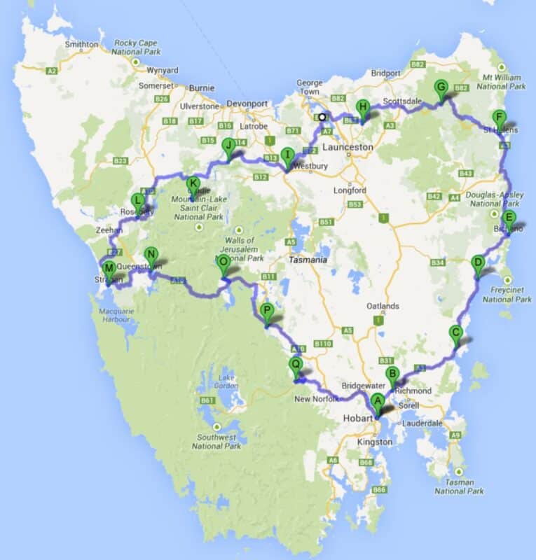
Day 0: Arrive in Hobart
Day 1: Hobart – Richmond (29km)
Day 2: Richmond – Triabunna (68km)
Day 3: Triabunna – Swansea (50km)
Day 4: Swansea – Bicheno (44km)
Day 5: Bicheno – St Helens (77km)
Day 6: St Helens – Derby (68km)
Day 7: Derby – Lilydale Falls (72km)
Day 8: Lilydale Falls – Launceston (30km)
Day 9: Launceston – Deloraine (51km)
Day 10: Deloraine – Gowrie Park (61km)
Day 11: Gowrie Park – Cradle Mountain (42km)
Day 12: Cradle Mountain – Rosebery (70km)
Day 13: Rosebery – Strahan (72km)
Day 14: Strahan – Lake Burbury (65km)
Day 15: Lake Burbury – Lake St Clair (73km)
Day 16: Lake St Clair – Wayatinah (59km)
Day 17: Wayatinah – Mt Field National Park (64km)
Day 18: Mt Field National Park – Hobart (75km)
Notes and cautions
Side trips
Port Arthur, Tasman Peninsula:
Maria Island:
Maria Island is a national park. It has no shops, no cars, and no electricity.
Activity: Swim, dive, explore convict ruins, visit the Fossil Cliffs, climb to the lookout at Bishop and Clerk or cycle 12Km along the western edge of the island on a dirt road past many attractive, deserted beaches to another basic camping area at the southern end of the island.Coles Bay, Freycinet National Park:
Dove Lake, Cradle Mountain:
Montezuma Falls:
A highly recommended side trip for MTB’ers is a quick detour to Tasmania’s highest waterfall, Montezuma Falls (at 113 m), just south of Rosebery. About 2 km south of Roseberry along the A10, turn off to Williamsford (6 km)along a sealed road. From there it is bikes and 4WDs only along an old train line. The 5 km track to Montezuma Falls is lovely, with large cuttings, a nice constant and gentle gradient and greenery all around. The return trip to the Falls from Roseberry takes about 3 hours.Gordon River Cruise, Strahan:
Lake St Clair:
From the camping ground at the southern end of Lake St Clair there are numerous day walks, but you’ll need a good raincoat, warm clothes, a day pack and walking shoes. Enquire at the Ranger Station about day walks. Alternatively, you could catch the shuttle boat from the jetty near the camping area to Narcissus Bay on the northern shore of the lake and walk back to the camping ground along a track through the rainforest (3+ hours, easy)