
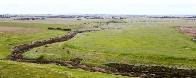
Work has started on the new 215-hectare Kororoit Creek Regional Park at Deanside, a park that not only will have numerous path and trails within, but will be exceptionally well connected to the bike network being developed for the region in the future.
The new park is immediately west of Caroline Springs and south of Fraser Rise, fronts onto the Western Freeway, is close to the Melton Rail line, and the Regional Rail Link, and naturally will be on the Kororoit Creek Trail when it is extended as part of the park plan.
The Kororoit Creek Trail, which will eventually connect from this location all the way through the Port Phillip Bay at Altona, is at this time only partially developed, but is magnificent in sections and will draw many people along it to visit this new park.
The park is planned to have an accessible network of walking tracks and shared paths throughout, complete with wayfinding and interpretive signage.
Two pedestrian/cycling bridges will provide opportunities for loop trails.
There will be informal trails down to the creek where it is safe to do so without impacting on environmental values and boardwalk will assist the protection of significant seasonal herbaceous wetlands.
Grasslands will be a feature of the park; however, canopy trees will be planted in the visitor areas, and along paths and trails where possible.
Because the terrain in the area is predominantly flat with a gentle slope, the trails will be suitable for a diverse mix of people with a range of needs, backgrounds and abilities.
Opportunities for additional connections to surrounding areas are provided by a high-pressure gas pipeline easement and a high voltage transmission line easement.
Planning for future new suburbs surrounding the park will be planned with bike networks that connect to and through the park.

The Kororoit Creek Trail link will likely be via Jamieson Link in Caroline Springs.
As well as the Kororoit Creek Trail, future strategic Cycling Corridors are planned for Neale Road through the park from Caroline Springs, and along the abutting Western Freeway
Some infrastructure within the park, such as shared pedestrian/cyclist bridges, will be funded by developers.
Planned residential development in the Kororoit, Mount Atkinson, Plumpton, Rockbank, Rockbank North, Rockbank South and Warrensbrook precincts will add an additional 150,000 residents to the region.
Adjoining the park to the north will be a future 45-hectare Nature Conservation Reserve, creating a total of 260 hectares of new green open space.
Become our friend
Find out more about Bicycle Network and support us in making it easier for people to ride bikes.