
Sorell Council has released a draft active transport strategy that sets an ambitious course for improved cycling connections through Sorell and the southern beaches communities.
The goal is to provide a cycling network over the next 10 years that will “provide the community with more sustainable and affordable methods to access the goods and services they need”.
Extensive public consultation resulted in several strong messages around cycling infrastructure:
- lack of bike paths in all towns in the municipality
- bike paths that do exist do not connect to other towns or housing
- lack of secure bike parking in Sorell
- poor attitudes from drivers
- people do not feel safe riding in many of the towns
- young people feel trapped and isolated.
The strategy provides a list of desired walking and cycling projects divided into short- medium- and long-term timelines: 1-3 years, 3-5 years and 5-10 years.
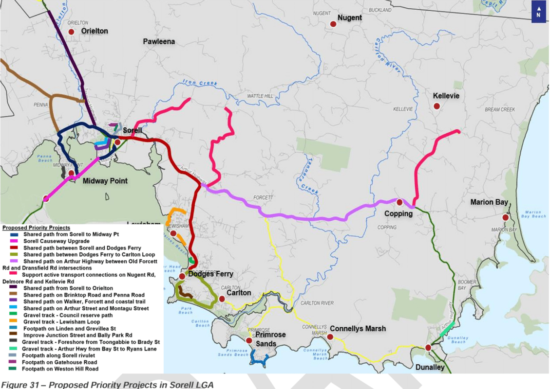
Shared paths between Dodges Ferry and Sorell and between Midway Point and Sorell have been repeatedly requested by the local community and have landed high in the priority list for short-term projects.
It’s a win for the Southern Beaches Mobility Group which formed a year ago to lobby for safer cycling paths through the area.
The Sorell to Midway Point path would follow the route: Main Road – Cole Street – Tasman Highway – Shark Point Road – Penna Road – Penna Beach Street – Sweetwater Road – Sandpiper Drive – Midway Point Esplanade – Lake Vie Parade – Sorell Causeway.
And the path to Dodges Ferry would be: Cole Street – Arthur Highway – Old Forcett Road – Carlton Beach Road/Carlton River Road intersection
In the medium-term list is a shared path from Sorell to Orielton and the long-term projects include shared paths connecting Dodges Ferry and Carlton, along the Arthur Highway to Copping, on Brinktop and Penna roads, and within Sorell.
Read the full draft strategy or one-page summary and fill out the survey before Sunday 23 June at www.sorell.tas.gov.au/sorell-active-transport-social-strategy/
Main image: Gary Houston