
Australia’s largest crowd-sourced bike safety project is complete and an interactive map is available for public viewing, offering valuable insights into where riders around the country feel safe and unsafe on their bikes.
Developed by crowd-sourced mapping firm CrowdSpot, BikeSpot 2023 launched in October last year, inviting the public to “make their mark” and add spots to a map indicating whether the location felt safe or unsafe to ride.
Users could also specify the infrastructure type, such as an on-road bike lane, separated lane or trail, add detailed descriptions and endorse comments made by other BikeSpot users.
The project drew almost 73,000 submissions from users around the country.
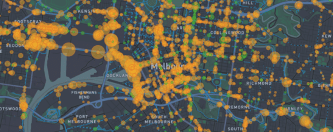
The interactive map displays location defined as safe by users with green bubbles and places defined as unsafe with amber bubbles. The larger the bubble, the higher the amount of submission activity.
A large green bubble can be found over the Princes Bridge, for example, where protected lanes have created separation for riders heading into the Melbourne CBD.
“Hooray for the protected lanes, so enjoyable to ride across the bridge now,” says “Julie” in a comment that attracted 28 supporters and three additional comments.
A large amber bubble, meanwhile, can be seen on Collins Street a couple of blocks away, where Steph comments “The bike lane is so narrow that I am just riding in the gutter,” attracting 29 supporters and 9 additional comments.
The hope is that these crowd-sourced insights from bike riders around the country can help advocates, researchers and planners build better places to ride and prioritise areas in need of improvement.
Still to come is the release of the National BikeSpot 2023 report and a “data download” feature so users can pull specific insights from the interactive map.
In the meantime, browse the map here.
Or become our friend and subscribe to receive our fortnightly newsletter.