

Consultation for the next stage of development of Droughty Point in Hobart’s south-east has opened, with cycling advocacy needed to ensure safe bike lanes are part of the final design.
Clarence Council is calling for public comment to inform a structure plan for the peninsula until 7 August.
The council’s structure plan process follows on from the Skylands masterplan released in late 2023, providing more detail for how the 25-year development will be delivered.
About 2600 homes are proposed for the peninsula to fill the gap in the market for medium density housing on the eastern shore.
Bicycle Network has been engaging with the developer from the beginning of the Skylands planning process to ensure active transport is considered.
The developers are proposing that Oceana Drive and its continuation around the peninsula will be the key active transport route, including bike lanes on both sides of the street separated from traffic by parked cars: https://skylands-hobart.com/plans/
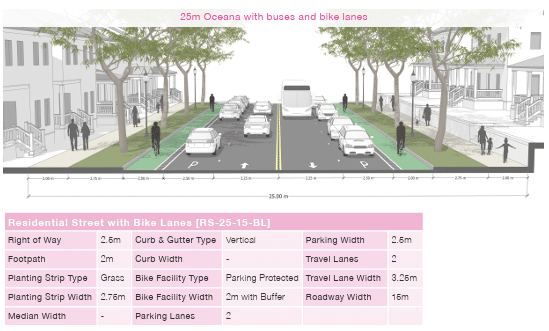
While this is a good outcome, the buffer between the parked cars and bike riders is not really wide enough so we’d like to see the planting strip width reduced to provide more space and either:
- Kerb and bollard separators or a planting strip between the bike lane and parked cars, or
- kerb-separated cycling path between the tree line and parked cars.
The From Street bike lane in Adelaide is a good example of what a separated bike lane using a planting separation strip could look like.

We’d also like to see a principle in the design parameters that where width is constrained, car parking is reduced to ensure bike lane widths are consistent and safe.
The council is saying the final designs for Oceana Drive will depend on topography and geological conditions.
There are several areas on the peninsula that have been identified as a current or future risk of landslip and other areas that have the potential to develop landslips. Slope steepness may also affect the developers’ ability to provide rear access lanes along Oceana Drive to reduce conflict points for people walking and riding.
Bike riders and would-be riders should let the council know they support the need for safe, consistent active transport connections through the development. This needs to be a non-negotiable during the design process, and overabundant visitor car parking provision shouldn’t override cycling safety.
Since the planning for Skylands first began, the state government has released guidelines for building active transport infrastructure and these should be used as part of the structure plan process.
From a recreational perspective, the structure plan is proposing to extend the Clarence Foreshore Trail around the peninsula as this was a strong community desire in previous rounds of consultation. Taswater also has wide buffer requirements around the foreshore to provide water and sewerage, which will provide more space for a trail.
There could also be bike trails along the top of the development, where open space parkland is proposed.
Read the background paper and fill out the survey via www.yoursay.ccc.tas.gov.au/droughty-peninsula-structure-plan
There is also a drop-in session schedule for Thursday 31 July at the Howrah Community Centre, 11 Howrah Road, between 3.30pm and 6.30pm.
Or become our friend and subscribe to receive our fortnightly newsletter.