
Bundaberg Regional Council is one of the latest municipalities to collect important transport data using Bicycle Network’s AIRS (Artificial Intelligence Road Survey) technology.
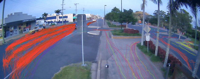
The surveys detect and categorise road users when they pass through the line of vision of the AIRS camera or sensor. The AIRS technology counts road users’ volume and speed, and tracks their movements along ‘trace lines’.
The project studied several key sites around the Boreham Park precinct in Avenell Heights and the Quay Street area in Central Bundaberg.
Sites in Boreham Park study aimed to understand the movement of bicycles and vehicles to and from the north of the park along streets that connect with Dunn Road.
Once the data is analysed, the study will provide insights into pedestrian movements to and from Boreham Park and a nearby café.
The Quay Street study focuses on the crossing movements of pedestrians in this precinct, while also providing insights into the bicycle and vehicle movements entering and exiting Quay Street from the connecting streets and carparks.
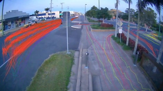
User path trace lines identified in the AIRS software at Quay Street and Walla Street, Bundaberg. (Yellow – Pedestrians, Pink – Bicycles, Red – Cars, Blue – Motorbikes, Brown – Large Goods Vehicle, Purple/Turquoise – Ordinary Goods Vehicle)
Bundaberg Regional Council is in the process of improving the region’s active transport network, as a part of their Active Transport Strategy 2020 - 2025, which aims to “connect people to places of importance such as the Central Business District, education facilities and sporting fields.”
This project builds upon the work Bicycle Network has already done with councils to collect data to improve active transport conditions for Australians.
A recent AIRS project completed in City of Port Phillip is providing transport planners with timely and accurate data to improve the bike riding and walking experience in the local area.
Bicycle Network have completed surveys using AIRS technology with over 20 municipalities, such as City of Yarra, City of Nillumbik, City of Darebin, and City of Maribyrnong.
These autonomous, AI-based road surveys are the newest addition to Bicycle Network’s suite of data collection services, which includes the long-established Super Tuesday commuter and Super Sunday recreational counts, and fully customised manual active transport surveys.
To find out more information about these services, or to book a free AIRS trial, visit our website and submit an enquiry.
You can also learn more about Vivacity Labs' AI sensors here.
Become our friend
Find out more about Bicycle Network and support us in making it easier for people to ride bikes.