
MAKE A SUBMISSION
By Alison Hetherington, Public Affairs Manager Tasmania
After years of arguing about building heights, the City of Hobart has released a draft Central Precincts Plan that also gives some indication of where it’s planning to build cycling infrastructure in the coming years.
The Central Precincts Structure Plan covers the 64 blocks between Davey Street, Brooker Highway, Burnett Street and Molle and Harrington streets.
The plan has been developed by the City of Hobart and the Tasmanian Government to govern medium density residential development and identify the infrastructure needed to cater to a growing population.
While the planning scheme does not have a height limit, the plan introduces an Urban Design Framework to provide guidance on building heights in different zones of the central precinct in an effort to protect heritage streetscapes.
Transport plans
The Precinct Plan contains goals and objectives that will direct the City of Hobart’s actions in a variety of areas.
Goal 4 is “integrated and accessible movement networks” and captures the improvements that are needed if more people are going to choose to move around by bicycle. Under that goal the following actions are listed to improve “micromobility”, which incorporates cycling.
- 56: Complete and connect the bicycle and micromobility facilities on the key corridors of Argyle Street, Campbell Street and Collins Street.
- 58: Identify further micromobility, pedestrian links and improvements that will improve connectivity and attractiveness in Central Hobart.
- 59: Continue to investigate micromobility options beyond the e-scooter trial.
- 60: Continue to support the provision of improved walking, cycling and micromobility facilities that will support more people to move around Central Hobart, catering for residential and employment growth mobility demands in the area.
Where will we ride?
The plan outlines which streets will have cycling infrastructure but not what it will look like. So while the lines on the map look promising, we don’t know yet how comfortable the cycling infrastructure put in place will be. This needs to be addressed so the Urban Design Framework has clear direction as to what type of cycling infrastructure is needed keeping in mind traffic volumes, speeds and parked cars.
Cities that have succeeded in getting more people riding do so by making bike travel the easiest and quickest option. The Central Hobart Precinct plan should be focussed on getting cycling routes into place that make riding people’s first choice to get around.
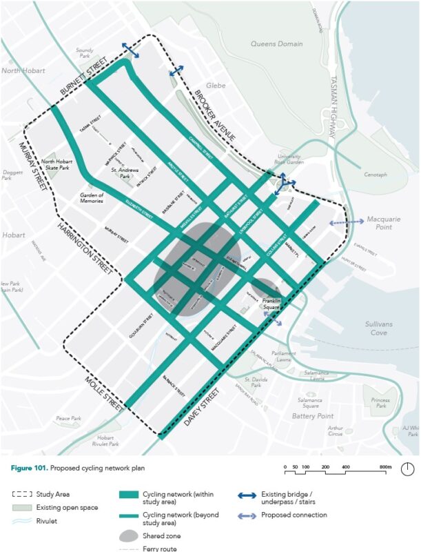
Interestingly, most streets look set to have some sort of cycling infrastructure rolled out, including one-way street couplets like Argyle–Campbell in acknowledgement of Hobart’s outdated one-way street set-up.
Davey Street is identified as a cycling route even though the government’s recently released bus stop–bus lane plans for the street offered just one block of painted lane alongside thousands of daily vehicle movements.
The plan makes it clear that the e-scooters will be expected to use the cycling infrastructure rather than the footpath, as is currently the case.
There is no mention in the plan of any upgrading of existing cycling treatments, such as getting rid of the painted lane in the dooring zone on upper Campbell and Argyle streets in favour of kerbside lanes with parked cars providing the barrier to traffic.
Central Hobart zone
The plan proposes to create a low-speed pedestrian zone in the Central Precinct, which is bordered by Collins, Bathurst, Harrington and Argyle streets.
This could be a good option for cycling providing it is designed well. Low-speed zones elsewhere in the world discourage car use in these zones.
Shared spaces also need clear direction for where bikes will go and space for them. The Liverpool Street block alongside Myers is an example of what not to do in a low-speed zone. It has no space allocated for people riding, there is constant risk of car dooring and bikes end up stuck in long lines of traffic.
The Liverpool Street block also suffers from very high traffic volumes which makes riding on the block unpleasant. Low-speed zones also need to be low-traffic zones if they are going to work for bike riders.
If the slow zone is going to work there needs to be clear direction for drivers away from the zone and little to no on-street car parking apart from essential purposes such as business deliveries and disability access so drivers are not attracted there.
Collins and Elizabeth streets
Collins and Elizabeth streets are two of the most popular routes for people riding as they have low traffic volumes, good gradients and. in the case of Elizabeth Street, the convenience of two-way direction.
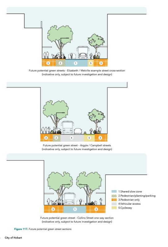
Both streets have been identified as cycling routes in the plan, but the type of infrastructure will be determined by the yet to be released “vision plans” for both streets. These are undoubtedly preferred routes for many people riding and there should be safe and convenient access and priority along both for bike riders.
They are mentioned in the plan as providing two-way travel for bikes, with Collins Street connecting the rivulet through to Macquarie Point and Elizabeth Street providing separated and shared solutions.
Bike parking
The plan outlines the needs for end-of-trip facilities and bike parking at ferry terminals and bus terminals, which is important seeing nothing has been done to allow bikes to be carried on buses despite the fleet now being accessible, low-floor models.
However, it doesn’t mention the need for bike parking throughout the central precinct. If people are going to be encouraged to swap car trips for electric bicycles, they need secure places to lock their bikes.
We should have the choice of cages or lockers or electronic docks or a mixture of all these operated by secure phone apps that ensure a high level of security on top of personal locks to deter theft.
Business owners should be encouraged to provide secure parking for employees and customers to complement the public parking.
For micromobility hire services to be more acceptable to the community there needs to be designated parking areas off the main footpath, and electric bicycles should be added to current electric scooter options as they are able to be used on more roads and can carry more than e-scooters.
Make a submission
The City of Hobart is calling for submissions to the draft plan via https://yoursay.hobartcity.com.au/central-hobart-plan before 30 April.
The key points to make in submissions are:
- The standard of cycling infrastructure needs to be articulated in the Urban Design Framework so we don’t get any more painted lanes in dooring zones. We want to see an All Ages and Abilities network through the city, as outlined in the Greater Hobart Cycling Plan.
- Shared zones still need to provide clear space for bicycles and will only work with very low speeds and very low traffic volumes. On-street car parking in such zones should be greatly reduced other than for loading and disability access so drivers are not attracted to the area.
- Streets surrounding the shared zone may see an increase in vehicle traffic so any cycling infrastructure on these needs to be physically separated.
- Electric bicycles should be added to the commercial micromobility options as they offer more comfortable journeys over longer distances and can be ridden on any road.
- Hobart needs secure bicycle parking to encourage more people on to electric bicycles, this could be in public cages, electronic docking locks or bike lockers accessible via secure phone apps. While this is important at public transport hubs like ferry and bus terminals, it should be available throughout the city.