
The narrow, unseparated bike lane creates a high risk of dooring and makes a bike ride down Chapel Street particularly harrowing, but advanced AI technology is collecting powerful insights into conflicts between road users.
Bicycle Network's AIRS (Artificial Intelligence Road Surveys) technology was deployed at a known trouble spot on Chapel Street in Windsor in July 2022 as part of a study with the City of Stonnington.
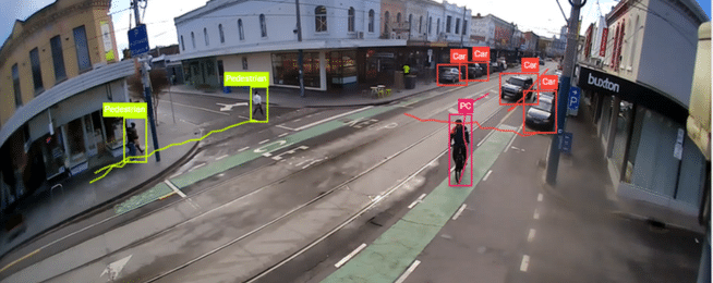
It aimed to measure the numbers and behaviour of different road users and identify any potential conflicts involving bike riders.
The AIRS technology achieves this by automatically detecting and categorising road users when they pass through an area, tracking both their speed and movement paths.
AIRS can detect potential conflicts by pinpointing the exact time a rider veers out of a bike lane and into a traffic lane, or when a vehicle turns across a bike lane and comes close to a rider.
Bicycle Network analyses footage of these incidents and determines whether they meet the criteria for a "conflict event" – where a rider or other road user has had to adjust their speed or position on the road to avoid a collision.
The survey focused on the intersection of Chapel, Union and James streets and captured a series of conflict events that paint a picture of regular risks to riders.
Chief among the identified risks to riders were south-bound, left-turning vehicles frequently crossing the path of riders in the bike lane.
Another common conflict occurred when vehicles performed reverse parallel parks, forcing riders across the tram lines and into the traffic lane. People stepping into the bike lane when exiting their vehicles and crossing the street were other common occurrences.
These findings will likely come as no surprise to those familiar with Chapel Street. The 2020 BikeSpot project revealed that Chapel Street was rated as the worst street to ride in Melbourne.
This AIRS study quantified the frequency of risks to riders at just one location on Chapel Street, offering a small but useful snapshot of road user behaviour.
Data collected through AIRS surveys is used to build reports into the actions of all road users, including turning movement volumes, path tracing and speeds of all types of road users. The type of expanded analysis carried out on Chapel Street provided important insights into how different road users were interacting and provided decision makers with a powerful tool for infrastructure planning and design.