
Port Phillip Council met last night to discuss its response to the Shrine to Sea masterplan, and whether it would ask for the re-inclusion of bike lanes within the project.
But the council meeting was heated and disrupted by residents against the plan.
The council won’t push for the inclusion of bike facilities in the masterplan, although it is set to receive an urban enhancement courtesy of $13 million from the state government.
The plan, out for a final round of public consultation, has dropped the proposed bike facility in Kerferd Road.
Port Phillip could have asked for the lanes to be included, in line with its transport policies for the street, but has declined.
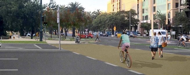
The Shrine to Sea draft masterplan is a concept that will transform the road into an attractive treed corridor for pedestrians and people on bikes.
The most recent draft has dropped the inclusion of bike facilities on Kerferd Road, a designated Strategic Cycling Corridor.
Bicycle Network CEO Alison McCormack says the street could provide for bikes, motor traffic and parking as well as a bio-diversity woodland in its median strip.
“For the Shrine to Sea project to be properly realised, Kerferd Road, has to be traffic calmed and reduced to two lanes, which would provide plenty of capacity for the traffic it carries,” McCormack says.
“The addition of a safe, separated bike lane will complete the picture and give the community the safe, calm street that is need to make this project work.”
“Bicycle Network will continue to engage with the community, the council and the government to develop this option,” she said.
Elsewhere along the corridor the focus on connectivity and active transport remains, with well-developed concepts in line with transport and environmental strategies of the state government and the City of Port Phillip.
The boulevard has been split up into eight zones stretching along Albert and Kerferd roads, while retaining a unified approach to an enhanced green boulevard.
“We are calling on all bike riders and active transport enthusiasts to respond to the consultation and ask that all eight sections include a separated bike lane,” says McCormack.
The section of road, to be called the Yannawatpanhanna boulevard, aims to "improve the varied resident and visitor experiences whether you walk, ride, drive or simply gather, sit and enjoy places along or through the boulevard”, the masterplan says.
"The Yannawatpanhanna boulevard will integrate with the new Anzac Station and landscaped public realm of the Domain precinct.
"A wider shared crossing at Kings Way with an additional designated bike crossing will bring people to a larger, more welcoming, gateway into Albert Park.
"Changes to the Moray Street intersection will improve access and safety for all users, clearly connecting bike riders to the Moray Street bike corridor, a key link to Melbourne’s CBD.
"Access and connectivity outside of South Melbourne Park Primary School will be enhanced with a formalised shared path and supplementary meandering paths, framed by low-height mounding and plants.
"The light rail pedestrian underpass entrances will be landscaped to improve sight lines, safety and awareness of this connection.”
The masterplan can be downloaded here. https://engage.vic.gov.au/shrinetosea
You can provide feedback through the website until 10 September 2023.
There are webinars on 21 and 27 August, 6:00 - 7:00 pm, with registration required.
Drop-in information sessions are scheduled on 19 and 23 August at the Mary Kehoe Community Centre Hall.
Become our friend
Find out more about Bicycle Network and support us in making it easier for people to ride bikes.