
After years of draft dreams, draft visions and draft masterplans, the 4km pedestrian and bike link along the Yarra north bank through the Melbourne CBD is closer to reality. Or a draft of reality, at least.
The final draft of the masterplan is now public for the $100 million worth of interconnected promenades, parks, open spaces, native planting, cultural activations and environmental renewal between Birrarung Marr and the Bolte Bridge.
You can have a look and give your feedback here.
With each stage, the planning has been increasingly based on research, technical assessments, design testing and feedback from stakeholders and the community.
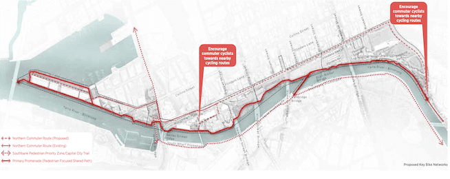
From the beginning the plan included the provision of access for bikes through north bank, although it was not designed as a quick commuter route.
For this to succeed, the City envisages a high-quality bike route along Flinders Street for commuters and through traffic, while the Greenline will be more visitor-focused, both for pedestrians and riders.

During recent consultation stakeholders expressed considerable fear of e-scooters making pathways risky for pedestrians, resulting in a shift in design focus.
The masterplan promises to "seamlessly connect the riverfront with the city, prioritising a pedestrian-focused shared path”.
"A key objective of the project is to create safe and clear access to, from, and along the north bank, including connections to the CBD,” states the masterplan.
"To balance movement along the promenade with new recreational activities along the river’s edge, we aim to deliver a low-speed environment that is safe for people to walk, ride bikes and use other forms of active transport.'
"The design of the Greenline Project will:
- discourage high-speed cycling and scooter riding and promote alternative routes for commuter cycling that are nearby. The development and ongoing management of the alternative routes are integral to the success of the pedestrian-focused shared path
- minimise conflict between pedestrians and other modes of active transport, including cycling, scooter riding, skateboarding and on-lead dog walking
- encourage the use of public transport infrastructure within the precinct
- support access to water transport and activities and consider future water-based transport options
- integrate intuitive signage, wayfinding and surface material selection that facilitates safe and accessible movement for all users
- provide parking space for cyclists and e-scooter users on the periphery of the project
- consider and adjust to the needs of wildlife
- follow the principles and opportunities relating to cycling in pedestrian-priority shared zones identified in City of Melbourne’s Transport Strategy 2030 and Design and Construction Standards • prepare a transport and movement strategy that focuses on establishing a safe, low-speed environment for all."
Become our friend
Find out more about Bicycle Network and support us in making it easier for people to ride bikes.