
The Tasmanian government has released a consultation masterplan for the expansion of the Hobart ferry service to six more sites along the River Derwent. So what does that mean for people riding?
The ferry service between Bellerive and Hobart is well sited along the Clarence Foreshore Trail and allows people to ride to the ferry along a safe, protected pathway.
Once at the ferry, 13-15 people can take their bikes on board or there is space for 11 bikes to be locked to a hoop outside the ferry terminal.
Bicycle Network plans to make a submission to the River Derwent Ferry Service Masterplan consultation, which closes on 8 January. Our goals are to emphasise the need for ferry terminals to have safe cycling access and secure bike parking; and for all new ferry designs to include easy bike ingress and egress, and ample on-board bike storage.
Where are the next ferry terminals?
Six sites have been prioritised from a list of 33. The proposed locations have been chosen for their ability to ease road congestion during peak hour commuting or events. Suitable water depth and weather conditions are also a consideration.
- Regatta Point
- Sandy Bay (Casino)
- Wilkinsons Point
- Howrah Point
- Lindisfarne
- Kingston Beach.
A key principle for the terminals will be reliance on passenger ability to walk, ride and scoot to each location. No extra car parking will be provided and sites have been chosen for their proximity to existing or planned paths.
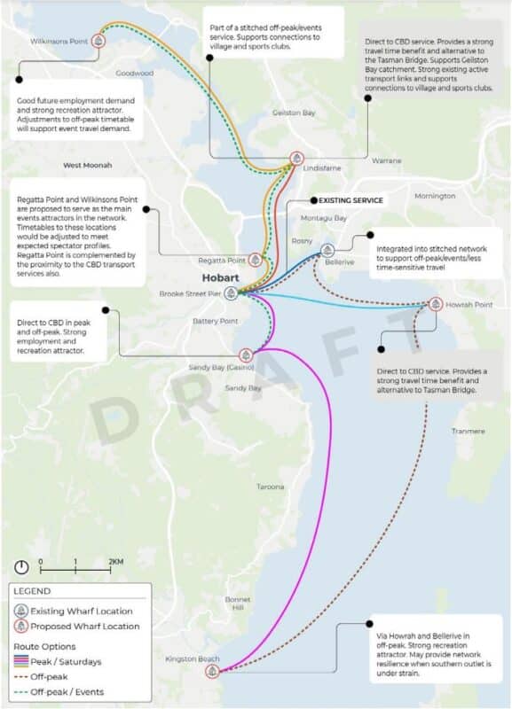
The proposed services include direct-to-Hobart commuter services during peak hours, and multi-stop services during off-peak and event periods.
Councils need to improve path access
The masterplan outlines the strengths and weaknesses of all sites considered. Of the six chosen sites only three are on a shared path. All sites will require improved path networks to ensure maximum connection to residential areas.
- Sandy Bay – this has the Sandy Bay on-road lanes, but these are not suitable for the majority of the population. There is a short shared path to the north and nothing from the west.
- Howrah Point – this needs to be joined to the existing sealed Clarence Foreshore Trail, less than 1km to its north and the unsealed Tranmere Coastal Reserve trail about 1km to its south.
- Kingston Beach – the path along Osborne Esplanade would need to connect to the breakwater. Ideally a path from the south/south-west is needed, but hilly, narrow roads make this difficult.
- Lindisfarne – is on the foreshore trail which provides good access but there are no shared paths connecting the bulk of the suburb to the foreshore trail.
- Regatta Point – this is well connected to the Intercity Cycleway and shared paths along the waterfront.
- Wilkinsons Point – this is connected to waterfront paths but needs a clear connection to the Intercity Cycleway. This link exists, but it needs to be improved and signed.
The masterplan acknowledges that ferries are more expensive to operate than buses, but says they can offer faster travel times, contribute to tourism and offer leisure activity options outside peak times. It also says terminals can trigger development and better pathway links.
Bicycle Network would like to see secure bike parking installed at Bellerive and all new terminals. Bike riders using ferry services leave their bikes unattended for many hours and providing more than just a hoop increases security. Secure bike parking could include cages, lockers activated by an app or swipe card, or electronic docks which remove the need to carry a lock.
Ferry design is not considered in the masterplan, but it is important to remind the government that existing ferries have been designed for foot passengers. Future ferries will require wider access for people with bikes, scooters, wheelchairs and other mobility devices, and covered spaces for bikes and mobility devices to be parked near seating areas. Separated access for foot passengers and passengers on wheels will help all passengers to get on and off ferries more quickly.
You can comment on the draft masterplan before 8 January 2024 via the online survey. The link allows attachment of documents for detailed feedback: https://engage.stategrowth.tas.gov.au/river-derwent-ferry-service-masterplan-consultation/draft-masterplan-feedback