
Whether you support or oppose the Macquarie Point Stadium you may be interested in commenting on draft guidelines that the Tasmanian Planning Commission has issued to shape the government’s application.
The Tasmanian Parliament has voted to send the assessment of the stadium precinct to the Planning Commission as per the State Policies and Projects Act 1993.
The Act requires the commission to prepare guidelines for the government (as the proponent) about the content it expects to see in reports that will be used to assess the project.
One or more of these reports will need to address movement, including how people walking and riding will get to the stadium, housing and other buildings in the precinct.
It has issued draft guidelines for public comment and will develop final guidelines before 16 February 2024, based on feedback.
Draft guidelines
Of relevance to cycling, Guideline 6: Movement asks the government to detail:
- Evidence and information on potential travel demand scenarios and travel demand management measures to be implemented and extended/adapted over time, including strategies and measures to support and encourage active transport
- A framework that enables travel demand scenarios, capacity creation, network management and behavioural change, and proposed travel demand measures to be implemented before and after the stadium starts operating
- Levels of confidence associated with mode share changes resulting from travel demand measures and the inner – waterfront precinct compared to the whole local – regional transport network.
Guideline 6.4: Pedestrian/Cycling Movement says government reports will:
- Discuss and present information on the origins/destinations, paths, volumes and networks associated with pedestrian and cycle movement
- Assess the physical connections and improvements and management arrangements with surrounding land and road owners required for pedestrians and cyclists to have safe, visible, amenable, direct and convenient routes when moving to and from the stadium and surrounding area
- Assess pedestrian/cycle conflict and crash risks and interventions.
Specific consideration is to be given to:
- The need for plans and management to minimise the likelihood of near misses or crashes between vehicles and pedestrians/cyclists, and to minimise pedestrian/cyclist conflicts
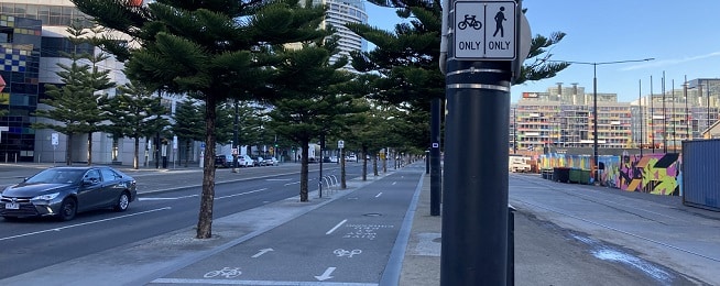
- The effect of high pedestrian use on cycle paths in and around Sullivans Cove
- The integration of pedestrian and cycling routes within the landscape and built form.
Other guidelines of relevance to cycling include:
1.1.1 The reports are to provide plans that include use and development related to roads or access ways used by vehicles, pedestrians and cyclists moving between the stadium building and the existing public road network; pedestrian/cycle pathways or standing areas; works or structures on existing road, pedestrian, cycle or public transport assets to cater for pedestrians, cyclists, altered traffic arrangements, mass/public transport vehicles.
1.3.1 The reports are to provide full details and plans of treatment of open spaces; new transport infrastructure to accommodate pedestrians, cyclists, vehicles and mass/public transport services; all changes to any existing transport infrastructure assets.
2.2.1 The scope of the policies and strategies to be addressed in reports include:
- Agreements or undertakings with local, state or federal governments and other organisations – this may include agreements such as the Hobart City Deal
- The Macquarie Point site precinct plan
- Proposed amendments to planning schemes
- City of Hobart plans and strategies, including active transport; parking and car parks; use and management of Council-owned reserves and parkland; strategies for pedestrian and cyclists; and the Central Hobart Plan
- The Department of State Growth’s policies and strategies regarding roads it owns or manages and plans for passenger transport infrastructure and services, including buses and ferries.
8.1.2 The reports are to consider the effects of wind on pedestrians, cyclists, and other people using open spaces.
Possible guideline changes
The key word in the guidelines is “safe”. The guidelines require the government to assess what is needed to provide people wanting to ride with “safe, visible, amenable, direct and convenient routes when moving to and from the stadium and surrounding area”. For some people, a painted line on a busy road next to parked cars is a safe cycling route, but for others it's nothing less than an off-road path.
The guidelines could specifically reference All Ages and Abilities (AAA) infrastructure. This standard of infrastructure is outlined in the Greater Hobart Cycling Plan and could be the basis for the commission’s assessment of whether cycling paths and lanes will give as many people as possible the choice of riding. This plan could be added to the list in Guideline 2.2.1, and AAA added before all mentions of cycling paths and its definition added to the glossary.
While there are many plans to improve cycling in Hobart, there is little funding available to make it happen and most of the land needed to create AAA routes is owned by local rather than state government.
Paths and cycleways in the precinct will only be as effective as those they connect to. The guidelines could require the government to provide likely construction timelines of AAA routes leading in to the precinct from Glenorchy, Clarence and Hobart areas and the government’s funding commitment to ensure they get built.
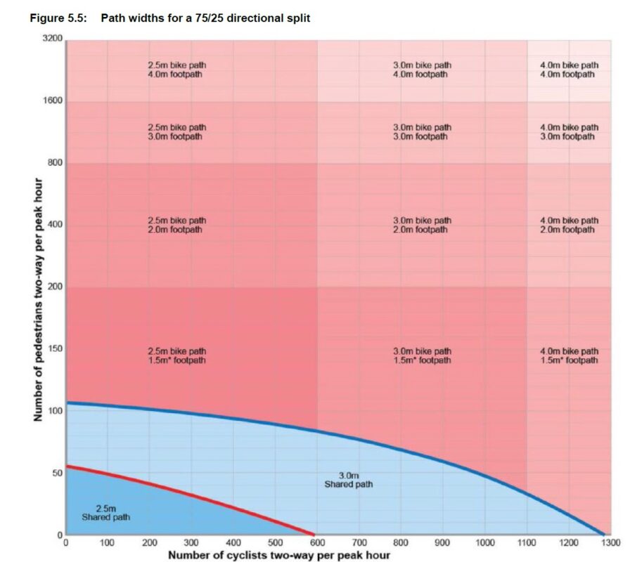
Guideline 6.4 highlights the potential for pedestrian and cyclist conflict and asks that reports assess the risk of this and details plans and management to minimise it. The guidelines could refer to the 2017 Austroads Guide to Road Design Part 6A: Paths for Walking and Cycling as it is clear about when pedestrians and cyclists/scooters should have separated paths to avoid conflict. This not only applies to paths within the precinct but also to paths leading into the precinct along popular routes such as the Intercity Cycleway and waterfront paths.
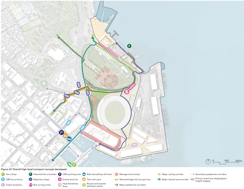
The Macquarie Point Development Corporation released a draft precinct plan for the site a few months ago, which shows where it’s thinking of placing routes for cycling: https://www.macpoint.com/_files/ugd/fa3c3b_117da99bc5924909aee0ef6da18f7e32.pdf
The guidelines do not mention bike parking, but secure parking in the precinct will be essential as people who feel their bike is safe from theft, especially more expensive e-bikes, are more likely to ride for transport.
Secure bike parking can be activated by swipe cards or mobile phone apps that require users to register with ID. The added layer of security can then be added to bike cages, bike lockers or electronic bike docks.
The Macquarie Point Draft Precinct Plan sets aside a small area for bike and scooter parking but doesn’t specify the standard of parking.
Guideline 6.4.2 could add another dot point: “the level of security of proposed bike parking infrastructure.”
Send your comments to the commission before 8 January 2024: tpc@planning.tas.gov.au.