
Burnie City Council has released a city centre plan that would put people who want to ride in a dangerous and uncomfortable position on some of its streets.
The Burnie City Centre Urban Plan professes a desire to make it easier to cycle through the city centre and several “green links” are marked on the map. Green links are described as shared paths but detail on the width of the paths is not provided and the cross-section diagrams for “city streets” only mention a “pedestrian space” of 2.5 metres.
To be useful as transport options, shared paths would need to be at least a clear 3 metres wide, but in a busy setting with a lot of pedestrians widths should be increased and people walking should be separated from people riding or scooting.
The proposed street designs also include a “city loop” that has painted lanes that are too narrow and sandwiched between parked cars and traffic.
Tasmanian government guidelines recommend using painted lanes only when traffic volumes are less than 400 vehicles in the busiest hour and moving at speeds of 30-40km or less.
If traffic conditions meet the low-volume, low-speed guidelines, then bike lanes should follow the City of Melbourne painted lane guidance, which is a bike lane of 1.5-1.8 metres in width, with a painted chevron buffer of 0.6-0.8 metres between parked cars and the bike lane.
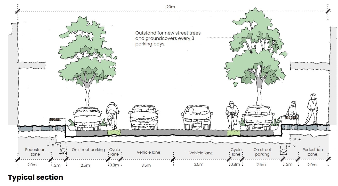
However, Burnie Council is proposing lanes on its city loop that are only 0.8 metres wide, next to parked cars with no buffer space. That’s 0.13 metres short of the minimum space required (see cross-section above).
The “operating envelope” width for a standard bicycle is 1 metre and for a cargo or trike bike it’s 1.2 metres. The proposed bike lane width doesn’t cover a moving bike, provide enough space to avoid debris or defects, account for wind buffering or allow room to pass another rider.
The proposed designs for the city loop provide a standard traffic traffic lane width of 3.5 metres and parking bay width of 2.5 metres. However, travel lane widths can be reduced to 3 metres on low-speed streets that don’t accommodate heavy vehicles and parking bay width to 2.1-2.3 metres.
Narrowing traffic lanes and parking bays would allow more space for people who want to ride. This would leave room for a painted lane on one side of the street – or on both sides of the street if some of the street furniture space was also reduced.
Let the council know its plans fail people who want to ride before 2 February via email burnie@burnie.tas.gov.au
More information can be found at:
- Tasmanian Cycling Infrastructure Design Guide
- City of Melbourne Bike Lane Design Guidelines
- https://austroads.gov.au/publications/road-design/agrd03 and https://austroads.gov.au/publications/road-design/agrd06a
- A 2890.5:1993 – Australian Standard Parking Facilities: On-street parking